Hydrological and water-quality monitoring, modelling and management
The centre’s Water Management team works closely with local communities and local government to monitor and manage water resources, including catchment hydrology, groundwater resources, estuarine dynamics, pollutant monitoring, desalination, water resource management and the impacts of climate change.
Our researchers have wide-ranging expertise with a particular strength in physical, numerical and machine learning modelling approaches.
Primary researchers
Lead
Water resource engineering, coastal/ocean dynamics, data modelling
Senior Lecturer
Coastal groundwater dynamics, ocean wave climatology, nearshore coastal processes, climate change
Senior Lecturer
Surface hydrology, climate change, water resources management
Senior Research Fellow
Data modelling, water resources management, climate change
Senior Lecturer
Coastal and oceanographic engineering, water resources engineering, climate change, data mining
Our expertise
- Physical and numerical modelling of coastal groundwater systems
- Numerical and data-driven modelling of climate change impacts on groundwater resources
- Climate change impacts on surface water resources
- Numerical modelling of surface water
- Physical and numerical modelling of evaporation from open water and mechanisms to reduce evaporation
- Sustainable energy technologies for seawater desalination.
Research themes
Catchments and waterways
Our catchments and waterways research programs focus on issues characteristic of human‐impacted coastal environments, such as river hydrological regimes, drought and flood regularity, and dissolved matter cycling.
Coastal and estuarine modelling
This research theme focuses on monitoring and modelling hydrodynamics and sediment movement, as well as water quality in support of effective management of estuaries and coasts.
Groundwater resources
Groundwater is an integral part of the global water balance and provides an important resource to serve potable and agricultural water demands. Groundwater also plays a critical role in sustaining ecological systems in a wide range of environments.
Our research in this theme focuses on interactions between the coastal ocean and aquifers, as well as the influence of climate change on groundwater resources.
Research projects
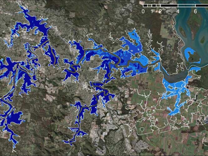
Impacts of climate change on streamflow and floodplain inundation in a coastal subtropical catchment
Climate change is expected to significantly alter river hydrological regimes throughout the world, affecting water resources and the frequency of floods and droughts. This study aimed to determine the impacts of climate change and sea level rise on streamflow and floodplain inundation in the subtropical Logan-Albert catchment in Queensland, Australia.
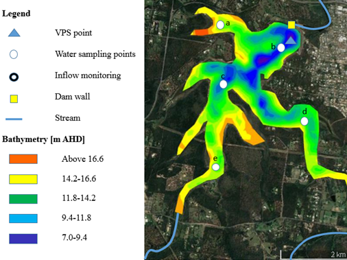
Coupled data-driven and process-based model for fluorescent dissolved organic matter prediction in a shallow subtropical reservoir
Monitoring and understanding the dissolved organic matter (DOM) cycle in drinking water reservoirs is crucial to water authorities, since most water treatment practices aim to remove DOM to prevent the formation of potentially harmful by-products during disinfection. A vertical profiling system (VPS) installed in reservoirs can continuously detect the presence of naturally fluorescent DOM (fDOM) and determine the fDOM transport process.
In the present study, we collected and analysed VPS and sampling data, then developed and assessed an innovative coupled data-driven and process-based model. These models were able to forecast future fDOM in both temperate and extreme weather conditions. Modelling scenario analysis concluded that deeper layers of the reservoir, as well as areas close to the riverine zone, had higher fDOM concentrations than any other zones during storm events
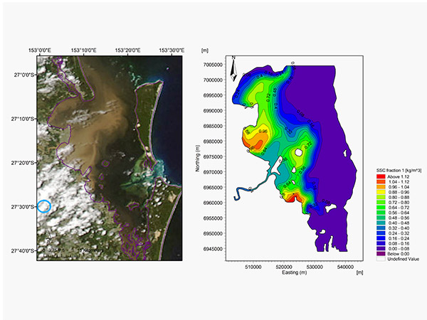
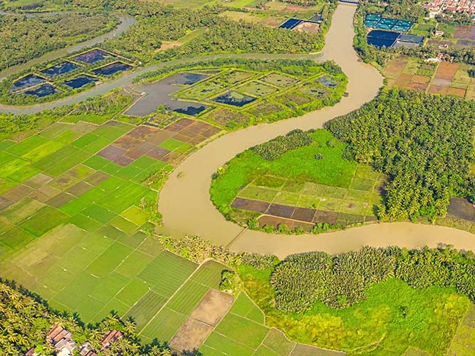
Sediment transport in a shallow coastal region following severe flood events
Severe floods usually result in harmful sediment and pollutant dispersion in shallow coastal regions. This study presents a three-dimensional hydrodynamic and transport model investigation into the sediment transport behaviour following severe flooding that occurred in the Brisbane River catchment. It was found that the flood-driven sediment plume formed in the adjacent Moreton Bay, then spread into the northern part of the bay. Based on analysis of the variations in horizontal sediment flux, four distinct characteristics of sediment transport were identified, corresponding to the combined effects of flooding runoff and tidal currents.
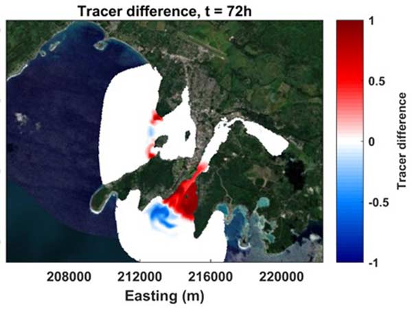
Water circulation and impact on water quality in a coral reef lagoon: Erakor Lagoon, Vanuatu
This study investigated flushing time in Vanuatu’s Erakor Lagoon and Port Vila Bay using a numerical model developed in Delft3D. Microbial contamination by Escherichia coli was detected in multiple locations in the lagoon system, with counts exceeding thresholds related to human health concerns. Modelling demonstrated a poor flushing time overall, with a further decrease as the influence of waves and wind increased, especially in Vila Bay. Sea level rise resulted in an increase in flushing time downstream of the lagoon near the open sea, while a decrease was observed upstream and in Vila Bay.
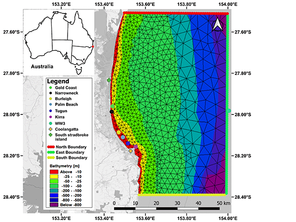
Spatial wave assimilation by integration of artificial neural network and numerical wave model
Ocean wave information is generally limited, particularly at nearshore. Attempts have been made to reconstruct spatial wave information, including using numerical wave models. The simulation results, however, often contain errors, making wave assimilation essential. This study aims to develop a spatial wave assimilation algorithm for significant wave height (Hs) and peaked wave period (Tp), using an artificial neural network (ANN) with data at a specific site.
Coastal Groundwater Dynamics
Coastal groundwater dynamics are induced by the interaction between the coastal ocean and the coastal aquifer. This interaction results in a dynamic response in the coastal aquifer that influences the availability and quality of the coastal groundwater resource and the mobility of sediments on beaches.
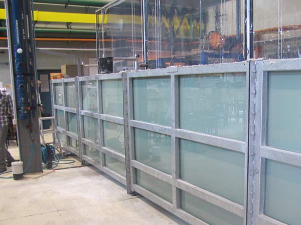
Our team uses physical and numerical modelling techniques to study these interactions. Our laboratory houses a 9 m x 1.5 m x 0.15 m groundwater flow flume, used to test and examine flow dynamics under a range of different forcing regimes.
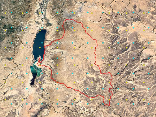
The influence of climate change on groundwater resources in the Dead Sea Basin, Jordan
The Dead Sea Basin in Jordan is in an arid climate, highly dependent on groundwater to meet potable and agricultural water demand. This project employs a blend of process-based groundwater modelling (MODFLOW) and machine learning method to examine the influence of climate change on the projected, sustainable groundwater yield.
Impacts of climate change on surface runoff, streamflow, evaporation and crop water requirements
Estimating the impacts of climate change on water resources is essential for efficient future water management. This is particularly important in Southeast Queensland (SEQ), Australia, a region projected to be significantly impacted by climate change. This project employs modelling and simulation to quantify the changes in surface runoff, streamflow, evaporation and crop water requirements in SEQ under climate change scenarios.
Additionally, physical and numerical modeling and simulation are used to investigate mechanisms to reduce water losses due to evaporation in regions with high evaporative demands.
For more information, as well as PhD opportunities, please contact project leader Dr Fernanda Helfer.
Sustainable energy technologies for seawater desalination
Seawater desalination has become one of the most important water treatment and drinking water production technologies in the world. Many desalination technologies, however, are associated with high investment costs, high energy consumption, and environmental pollution. This project aims to conceptualise, investigate and model innovative seawater desalination technologies such as FO-RO, UF-RO, PRO-RO and membrane distillation, while also assessing their energy, environmental and economic performance.
For more information, as well as PhD opportunities, please contact project leader, Dr Fernanda Helfer.

Partnerships
SEQwater is the Queensland Bulk Water Supply Authority responsible for delivering safe, secure and cost-effective bulk water supply for more than three million people across South East Queensland.
Our team collaborates with the City of Gold Coast to study the impacts of climate and land cover change on hydrological processes and water quality at the Nerang Catchment.
Our team is undertaking collaborative research with Logan City Council to assess the impacts of climate change on streamflow and floodplain inundation in the Logan Catchment.
Water Technology provides expert insight and practical solutions for surface water, groundwater, coastal and environmental challenges. We work with this consultancy to conduct studies on nearshore wave simulations and wave characteristic analysis during extreme events.
JBPacific is a part of the JBA Group, focusing on natural disasters throughout the Pacific region, and solutions to minimise the impact of floods, cyclones, typhoons, storm tides and erosion. We have collaborated with them on studies including flood prediction, beach erosion and riverbank erosion.
Contact details
- Phone
- (07) 5552 7269
- Location and postal address
- Coastal and Marine Research Centre
- Room 2.01, Building G51
- Griffith University
- Gold Coast, Queensland, 4222